How AI and Satellites Are Revolutionizing Wildfire Early Detection
Artificial intelligence networks and geostationary satellites are now detecting wildfires within minutes of ignition, shifting disaster management from reactive to proactive.
By Factlen Editorial Team
- Fire Managers & First Responders
- Advocate for the fastest possible detection to enable successful initial attacks and protect crews.
- Utility Companies
- Focus on deploying AI to monitor grid infrastructure, prevent ignitions, and reduce financial liability.
- AI & Tech Developers
- Emphasize the rapid advancement, global scalability, and high accuracy rates of machine learning models.
- Ecological Scientists
- Warn that hyper-efficient fire suppression must be balanced with the ecological need for natural burns.
What's not represented
- · Homeowners in high-risk wildland-urban interface zones
- · Insurance companies adjusting premiums based on AI mitigation
Why this matters
Catching a wildfire in its first few minutes can mean the difference between a minor brush fire and a billion-dollar catastrophe. By automating the lookout process, communities can deploy resources faster, saving lives, property, and critical infrastructure.
Key points
- AI-powered camera networks are acting as digital lookout towers, scanning forests 24/7 for smoke anomalies.
- NOAA's satellite-based AI system can detect the thermal energy of a fire in as little as one minute.
- Early detection in a single Oklahoma outbreak saved an estimated $850 million in property.
- Utility companies are heavily investing in the technology to monitor transmission lines and reduce liability.
- AI systems still face challenges with false positives, occasionally confusing clouds or exhaust for smoke.
- Ecologists warn that while early detection is vital, some remote fires must still be allowed to burn to clear underbrush.
For decades, the first line of defense against catastrophic wildfires has been human vigilance. Staffed lookout towers, routine aerial patrols, and 911 calls from passing motorists were the primary ways fire agencies learned that a forest had ignited. But in an era of prolonged droughts and accelerating fire seasons, human observation is no longer fast enough. By the time a plume of smoke is large enough to be spotted by a distant hiker or a passing driver, the blaze may have already grown beyond the capacity of an initial attack crew.
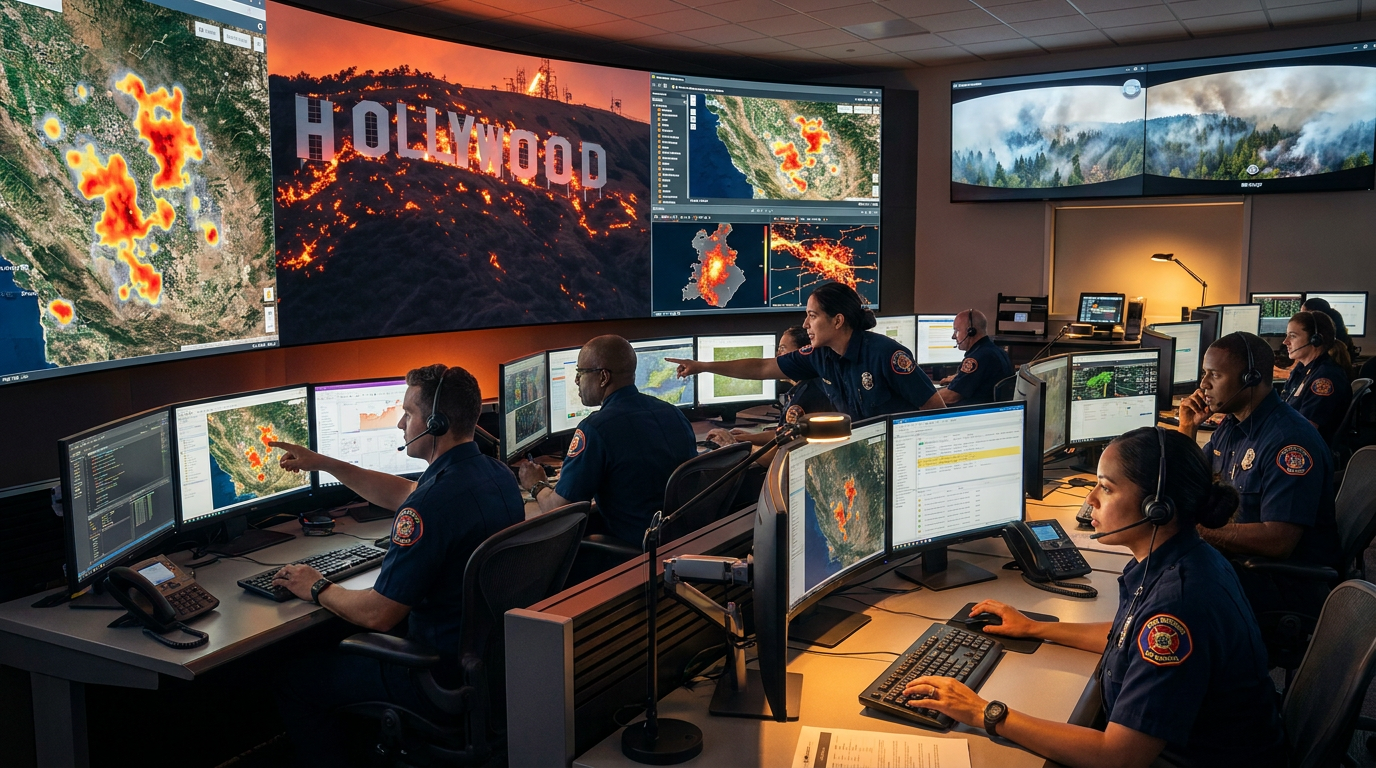
That paradigm is now shifting rapidly. Across North America and Australia, a new generation of "digital lookout towers" is taking over the watch. Powered by artificial intelligence, high-definition camera networks, and geostationary satellites, these automated systems are scanning the wilderness 24 hours a day, seven days a week. They are detecting ignitions in as little as one minute, fundamentally altering the math of wildfire containment.[4][7]
The mechanism relies on a fusion of hardware and advanced machine learning. On mountaintops and utility towers from Alberta to Arizona, high-definition cameras continuously pan across the landscape. These cameras capture a full 360-degree panoramic photograph every few minutes. The AI software then compares each new image to the previous one, scanning the pixels for any anomaly that resembles a smoke column.[1][2][3]
When the algorithm detects a potential fire, it flags the image and instantly sends an alert to a command center. There, a human operator or fire dispatcher double-checks the visual evidence before scrambling emergency resources. This technology is proving especially critical during nighttime lightning storms, when human recreation and logging operations have ceased, leaving the forests empty but vulnerable.[2]

Utility companies, which face immense liability if their infrastructure sparks a blaze, are among the most aggressive early adopters. In Arizona, the Maricopa County Department of Emergency Management and Arizona Public Service recently showcased a network of AI-powered smoke detection cameras monitoring the wildland-urban interface. Similarly, in Alberta, Canada, utility providers like AltaLink and ATCO Electric have been testing AI cameras near their transmission lines. In one instance, a camera detected a fire start that crews extinguished within an hour; post-fire analysis revealed it would have grown out of control if left burning for just 60 more minutes.[1][3]
While ground-based cameras look for smoke, a parallel revolution is happening in space, looking for heat. The National Oceanic and Atmospheric Administration (NOAA) has deployed an experimental Next Generation Fire System (NGFS) that leverages the Advanced Baseline Imager on GOES geostationary satellites. Orbiting 22,000 miles above the equator, these satellites generate a fresh image of the entire contiguous United States every five minutes.[4]
The NGFS algorithms continuously comb through enormous volumes of satellite data, automatically identifying heat anomalies or "hot spots" even through cloud cover and smoke. Any new source of heat is overlaid on surface imagery, geolocated, and pushed to an online dashboard. The system can provide alerts in as little as one minute from the time the fire's thermal energy reaches the satellite, successfully detecting fires as small as a quarter of an acre.[4]
Any new source of heat is overlaid on surface imagery, geolocated, and pushed to an online dashboard.
The economic and safety implications of this orbital early warning system are staggering. During a recent spring wildfire outbreak in Oklahoma, state officials reported that GOES satellites provided the initial detection for 19 separate fires. Rapid firefighter response, triggered by these automated alerts, likely saved more than $850 million worth of structures and property. The total cost to develop the NGFS was under $3 million.[4]

Beyond initial detection, AI is also transforming how active fires are tracked and communicated to the public. Tech giants like Google have integrated AI wildfire tracking into their mapping platforms. By fusing satellite imagery with weather data and historical models of "fire scars"—the blackened earth left behind by previous burns—Google's AI can precisely measure a fire's boundaries and predict its spread. This allows residents to check their mapping apps for real-time evacuation zones and air quality indexes, helping communities avoid hazardous smoke plumes.[5]
Private AI developers are also pushing the boundaries of global deployment. Companies like Alchera X, the developer of the FireScout AI detection system, have partnered with emergency response networks in Australia, Spain, Italy, and South Korea. By continuously learning from every confirmed or dismissed fire across thousands of square miles, these mature systems claim accuracy rates approaching 99.9%, significantly reducing the false positives that plague earlier iterations.[6][7]
However, the technology is not without its growing pains and controversies. In California, which recently suffered a devastating start to its 2025 fire season with over 40,000 acres burned, debates have erupted over which AI platforms to trust. Developers have publicly questioned the state's decision to transition between different detection vendors, arguing that gaps in detection capabilities during the switch may have worsened the impact of the fires.[6]

Furthermore, algorithmic detection still faces environmental hurdles. Researchers working with Alberta Wildfire note that AI systems can sometimes be fooled by visual disturbances that mimic smoke. Low-hanging clouds, morning fog, or even a large truck spouting a plume of exhaust can trigger false positives. In controlled tests, experienced human lookout observers have sometimes outperformed early-stage AI in distinguishing true wildfires from innocuous atmospheric phenomena.[1]
There is also a complex ecological debate surrounding the efficiency of early detection. Paradoxically, catching every single fire immediately is not always the best long-term strategy for forest health. Forestry scientists point out that allowing fires to burn in remote areas, far from human habitation, clears out dense underbrush and dead vegetation. These natural "burn scars" act as vital firebreaks that can stop future, more catastrophic blazes.[2]

This creates a difficult trade-off for fire managers. The AI systems provide the data instantly, but humans must still make the tough call on whether to suppress the fire immediately or let it perform its natural ecological function. As one U.S. Forest Service scientist noted, managers are constantly juggling the short-term risk of a burning fire against the long-term risk of an overgrown, highly flammable forest.[2]
Despite these nuances, the consensus among emergency responders is overwhelmingly positive. The transition from human reliance to AI-assisted monitoring represents one of the most significant leaps in wildland firefighting in decades. By providing a critical early jump on ignitions, AI and satellite networks are giving firefighters the one resource they need most when a forest catches fire: time.[1][2][4][7]
How we got here
Historical
Wildfire detection relied almost entirely on human lookout towers, aerial patrols, and civilian reports.
2021-2023
Early pilot programs paired high-definition mountaintop cameras with initial machine learning algorithms to spot smoke.
2024
Tech companies like Google expanded AI boundary tracking and air quality integration to over a dozen new countries.
Spring 2025
NOAA's Next Generation Fire System proved its economic value, saving $850M in property during an Oklahoma outbreak.
Summer 2026
Utility companies across North America rapidly scale their deployment of AI camera networks to protect grid infrastructure.
Viewpoints in depth
Fire Managers & First Responders
Focused on the tactical advantage of early intervention to keep fires small.
For incident commanders and dispatchers, the primary value of AI is time. Catching a fire when it is only a quarter-acre in size allows crews to mount a successful 'initial attack' with a single engine or helicopter. If detection is delayed by even an hour, the fire can crown into the canopy and require a massive, multi-agency response that puts hundreds of firefighters at risk.
Utility Companies
Driven by the need to protect grid infrastructure and mitigate legal liability.
Power providers are aggressively funding and deploying these camera networks along their transmission corridors. Because utility-sparked fires have historically caused some of the most destructive and legally costly disasters, companies view AI monitoring as a critical insurance policy. It allows them to detect sparks from failing equipment instantly and shut down local grids before a catastrophic blaze takes hold.
Ecological Scientists
Concerned with balancing short-term suppression against long-term forest health.
Forestry researchers emphasize that a 100% suppression rate is ecologically dangerous. Decades of putting out every fire has led to an unnatural buildup of dead wood and dense underbrush. While they support AI for protecting the wildland-urban interface, they argue that fire managers must use the technology's data to confidently let remote, low-risk fires burn, creating natural firebreaks for the future.
What we don't know
- How effectively AI algorithms will adapt to entirely new fire behaviors caused by unprecedented climate shifts.
- Whether the cost of maintaining vast high-definition camera networks will be sustainable for smaller, rural fire districts.
- How state agencies will resolve vendor disputes and standardize AI detection platforms across overlapping jurisdictions.
Key terms
- Geostationary Satellite
- A satellite that orbits at the same speed the Earth rotates, allowing it to continuously monitor the same geographic area.
- Initial Attack
- The first, aggressive response by firefighters to a new ignition, aimed at containing the blaze before it grows.
- Wildland-Urban Interface
- The zone where human development meets or intermingles with undeveloped natural land, representing the highest risk for property damage.
- Fire Scar
- The blackened, burned area left behind after a wildfire, which AI models use to track historical spread and predict future firebreaks.
- False Positive
- An instance where an AI system incorrectly identifies a harmless anomaly, such as a cloud or exhaust plume, as a wildfire.
Frequently asked
How fast can AI detect a new wildfire?
Advanced AI systems, using either satellite thermal imaging or ground-based cameras, can detect a fire and issue an alert in as little as one minute.
Does AI replace human firefighters?
No. AI acts as an early warning system. Human dispatchers still verify the alerts, and human crews are required to actually fight and contain the fires.
Can AI cameras see fires at night?
Yes. Many AI camera networks utilize infrared technology, and satellite systems rely on thermal energy, allowing them to detect fires in pitch darkness.
Why would we ever let a wildfire burn?
Ecologists note that low-intensity fires in remote areas clear out dead brush. If all fires are suppressed, the built-up fuel can lead to catastrophic, uncontrollable blazes later.
Sources
Source coverage
7 outlets
4 viewpoints surfaced


[1]CBC NewsUtility Companies
Alberta utilities testing AI cameras to spot wildfires
Read on CBC News →[2]Boise State Public RadioEcological Scientists
AI cameras act as digital lookout towers in Idaho wilderness
Read on Boise State Public Radio →[3]Daily DispatchUtility Companies
New AI cameras will soon help APS monitor for wildfires across Arizona
Read on Daily Dispatch →[4]NOAAFire Managers & First Responders
Early success of AI-powered fire detection system is winning fans in firefighting community
Read on NOAA →[5]ZDNETAI & Tech Developers
How you can use Google Maps to track wildfires and air quality
Read on ZDNET →[6]Fire and Safety Journal AmericasAI & Tech Developers
Alchera X questions technology switch amid wildfire crisis
Read on Fire and Safety Journal Americas →[7]GlobeNewswireAI & Tech Developers
Alchera X Highlights Success of FireScout AI Integration with WatchTowers Network
Read on GlobeNewswire →
Every angle. Every day.
Get environment stories with full source coverage and perspective breakdowns delivered to your inbox.