How Satellite Data is Decoding the Climate Volatility Behind the 2026 Himalayan and Karakoram Disasters
High-resolution satellite imagery has confirmed that extreme climate volatility drove the spate of early 2026 mountain disasters, accelerating the development of next-generation early warning systems.
By Factlen Editorial Team
- Remote Sensing Scientists
- Advocate for continuous, multi-source satellite monitoring to understand complex glacier dynamics.
- Disaster Risk Managers
- Focus on translating satellite data into actionable early warning systems and hazard maps.
- Downstream Stakeholders
- Emphasize the cascading impacts of high-altitude climate volatility on water security and agriculture.
What's not represented
- · Hydropower Operators
- · High-Altitude Mountaineering Guides
Why this matters
The Hindu Kush-Himalaya region acts as the water tower for nearly two billion people. By shifting from reactive disaster response to predictive satellite monitoring, scientists are finally gaining the ability to forecast mountain hazards and secure the water supply for downstream communities.
Key points
- Early 2026 saw a spate of Himalayan disasters driven by extreme climate volatility, not just seasonal melting.
- Satellites using feature-tracking algorithms recorded Karakoram glaciers surging at nearly 57 meters per year.
- Geospatial assessments confirmed the rapid expansion of high-risk glacial lakes, pushing moraine dams to their breaking points.
- Synthetic Aperture Radar (SAR) allows scientists to monitor millimeter-level rock deformations through thick cloud cover.
- Swiss and Indian researchers are using this data to build predictive early warning systems for downstream communities.
- The volatility of surface meltwater is forcing downstream agricultural basins to rapidly deplete their groundwater reserves.
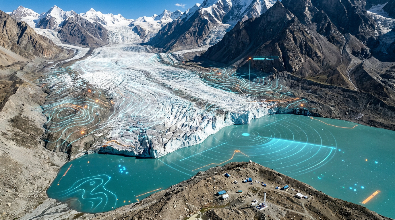
In early 2026, a devastating series of sudden ice avalanches and glacial lake outbursts struck the Himalayan and Karakoram mountain ranges, displacing communities and threatening critical infrastructure. While initial reports attributed the events to routine seasonal melting, a new wave of high-resolution satellite data has confirmed a far more complex and actionable culprit. The data reveals that extreme climate volatility—characterized by rapid temperature swings, irregular winter precipitation, and sudden heat spikes—destabilized massive ice structures long before the traditional spring thaw. This confirmation marks a turning point in how scientists understand the mechanics of high-altitude hazards, shifting the focus from gradual warming to violent, unpredictable atmospheric shifts.[2][6]
Historically, monitoring the "Third Pole"—the vast expanse of ice spanning High Mountain Asia—relied on sparse, difficult-to-maintain ground stations. The sheer scale and ruggedness of the terrain left massive blind spots in disaster prediction. Today, however, constellations of optical and radar satellites are providing a millimeter-level view of the mountains. By synthesizing thousands of images from Sentinel, Landsat, and ICEYE satellites, geospatial intelligence firms and academic researchers have been able to track the exact mechanisms that triggered the early 2026 events, offering a forensic look at how climate volatility physically alters the mountains.[1][3][4]
The satellite data has brought one specific phenomenon into sharp focus: the Karakoram Anomaly. Unlike the rapidly retreating glaciers of the eastern Himalayas, many glaciers in the Karakoram range are "surge-type" glaciers. Rather than simply melting away, these massive rivers of ice periodically accelerate to up to 100 times their normal speed, advancing violently down valleys. While this anomaly has been observed for decades, the 2026 data revealed how acute climate volatility acts as a trigger, with sudden influxes of meltwater lubricating the bedrock beneath the ice and initiating catastrophic surges.[3][6]
To track these surges, researchers employ advanced feature-tracking algorithms, such as autoRIFT, which analyze sequential satellite images to measure the velocity of the ice. Prior to the 2026 disasters, satellites detected a distinct and ominous pattern in several high-risk Karakoram glaciers: a prolonged period of deceleration followed by a sudden, violent acceleration. This velocity data, which recorded some glaciers moving at nearly 57 meters per year, provided the first definitive proof that the ice was structurally failing under the stress of erratic temperature fluctuations.[3][6]

As these glaciers surge or retreat, they leave behind another profound hazard: Glacial Lake Outburst Floods (GLOFs). Meltwater pools at the terminus of the glacier, forming massive high-altitude lakes held in place only by fragile dams of loose rock, dirt, and debris known as moraines. When an ice avalanche or a sudden surge displaces the water in these lakes, the moraine dam can rupture, sending a wall of water, mud, and boulders roaring down the valley. The 2026 satellite assessments revealed that several of these lakes had expanded at an alarming rate due to the volatile winter melt.[1]
A recent analysis by geospatial intelligence firms examined high-risk lakes in the eastern Himalayas, comparing their extent from 2016 to mid-2026. The satellite imagery confirmed that lakes such as Sanhapo had grown significantly, expanding to nearly 89 hectares. This sustained expansion, driven by the erratic climate, pushed the moraine dams to their absolute breaking point. The data underscores that it is not just the volume of the meltwater, but the suddenness of its accumulation during volatile weather spikes, that triggers these deadly outbursts.[1][6]

A recent analysis by geospatial intelligence firms examined high-risk lakes in the eastern Himalayas, comparing their extent from 2016 to mid-2026.
To understand the sheer volume of water and ice involved in these systems, scientists rely on satellite altimeters like Jason-3 and ICESat-2. These highly specialized instruments bounce lasers or radar pulses off the Earth's surface, measuring elevation changes down to the centimeter. By comparing altimetry data over time, researchers can calculate exactly how much mass a glacier is losing, or how rapidly a glacial lake is deepening, providing a crucial three-dimensional understanding of the accumulating risk.[3]
However, optical satellites and laser altimeters share a critical vulnerability: they are often blinded by the thick clouds and snowstorms that accompany severe climate volatility. To pierce through the weather, scientists turn to Synthetic Aperture Radar (SAR). SAR satellites emit microwave pulses that pass through cloud cover and darkness, reflecting off the ground to detect millimeter-level shifts in rock and ice. This continuous, all-weather monitoring is what allowed researchers to track the impending failures in early 2026 even when the mountains were shrouded in winter storms.[4]
The confirmation of climate volatility as the primary driver of these events has catalyzed a major shift in how governments approach mountain safety. The raw satellite data is now being operationalized into predictive tools. Researchers from the Swiss WSL Institute for Snow and Avalanche Research have partnered with Indian authorities to build next-generation early warning systems. By feeding SAR and optical data into advanced computer simulations, these teams are mapping exactly where a potential rockslide or ice avalanche will travel, and how long it will take to reach populated areas.[4]

These predictive models represent a massive leap forward in disaster risk reduction. When a satellite detects a sudden acceleration in a glacier or a millimeter-level deformation in a rock face, the simulation can instantly calculate the downstream impact. This allows authorities to issue targeted evacuation orders for specific valleys, rather than relying on broad, regional warnings that often lead to alert fatigue. In some cases, the data even provides enough lead time to artificially drain expanding glacial lakes before they breach.[4][6]
Despite this technological renaissance, significant uncertainties remain. Predicting the exact moment a moraine dam will rupture or an ice cliff will collapse is still incredibly difficult. The complex interactions between subsurface meltwater routing, geothermal heat, and local tectonic activity create hidden variables that even the most advanced radar cannot fully penetrate. Scientists caution that while satellites can identify the loaded gun, they cannot always predict exactly when the climate will pull the trigger.[3][6]
The stakes of mastering this predictive technology extend far beyond the immediate disaster zones. The Hindu Kush-Himalaya and Karakoram ranges act as the "water tower" for nearly two billion people across Asia. The extreme climate volatility that causes these sudden disasters also disrupts the steady, reliable flow of meltwater that downstream agricultural basins depend on. When the water comes as a destructive flood rather than a steady seasonal flow, it devastates crops and infrastructure alike.[5]
This surface water volatility is triggering a secondary, hidden crisis underground. Satellite gravity measurements have revealed that as river flows become more unpredictable, downstream communities are rapidly depleting their groundwater reserves to compensate. The data points to an average loss of around 24 billion tonnes of groundwater each year in the region. This interconnected cascade—from a surging Karakoram glacier to a drying well in the plains—highlights the profound, continent-wide impacts of high-altitude climate volatility.[5][6]

Ultimately, the events of early 2026 serve as a testament to human ingenuity in the face of a changing planet. The rapid deployment of satellite technology has illuminated the mechanics of these mountain hazards as never before, proving that the impacts of climate change are no longer an invisible threat. By transforming space-based data into actionable, ground-level early warning systems, scientists and policymakers are taking the first crucial steps toward adapting to the new, volatile reality of the world's highest peaks.[1][4]
How we got here
1990s–2010s
Ground-based observations identify the 'Karakoram Anomaly,' noting that glaciers in this specific region are surging while others retreat.
October 2023
The catastrophic South Lhonak Lake outburst in Sikkim highlights the urgent need for continuous, space-based monitoring of glacial lakes.
2024–2025
Space agencies and geospatial firms deploy advanced feature-tracking algorithms across thousands of satellite images to map ice velocity.
Early 2026
A spate of ice avalanches and floods strikes the region; satellite data definitively links the events to acute climate volatility.
June 2026
Swiss and Indian researchers announce significant progress on a next-generation, satellite-driven early warning system for Himalayan communities.
Viewpoints in depth
Remote Sensing Scientists
Advocate for continuous, multi-source satellite monitoring to understand complex glacier dynamics.
For glaciologists and remote sensing experts, the 2026 data represents a triumph of multi-modal observation. They argue that relying solely on optical imagery is insufficient, as cloud cover often obscures the mountains during critical weather events. By integrating Synthetic Aperture Radar (SAR) and laser altimetry, these scientists emphasize that we can now measure millimeter-level deformations in rock and ice in real-time. Their primary focus is on refining feature-tracking algorithms like autoRIFT to better understand the underlying physics of glacier surges and moraine failures.
Disaster Risk Managers
Focus on translating satellite data into actionable early warning systems and hazard maps.
Agencies responsible for downstream safety view the satellite data not just as scientific observation, but as a critical public safety tool. Their priority is operationalizing the raw velocity and elevation data into predictive computer simulations. By partnering with international research institutes, these managers argue that we can move from a reactive posture to a proactive one—issuing targeted evacuation orders and even artificially draining high-risk glacial lakes before they breach. They stress that the technology is only as good as the communication networks that deliver the warnings to remote valleys.
Downstream Stakeholders
Emphasize the cascading impacts of high-altitude climate volatility on water security and agriculture.
For the millions of people living in the agricultural basins fed by the Himalayan and Karakoram meltwater, the primary concern is water security. These communities argue that while early warning systems for floods are vital, the broader issue is the extreme volatility of their water supply. As erratic melting disrupts seasonal river flows, farmers are forced to over-extract groundwater, leading to a massive, unsustainable deficit. They advocate for comprehensive climate adaptation strategies that address both the acute risk of flash floods and the chronic threat of water scarcity.
What we don't know
- The exact moment a moraine dam will rupture under the stress of a swollen glacial lake.
- How subsurface geothermal heat interacts with meltwater to trigger sudden glacier surges.
- Whether the Karakoram Anomaly will persist as global temperatures continue to rise over the next decade.
Key terms
- Glacial Lake Outburst Flood (GLOF)
- A sudden, catastrophic release of water from a lake formed by glacier melt, usually triggered when its natural rock dam fails.
- Karakoram Anomaly
- The unusual phenomenon where glaciers in the Karakoram range are remaining stable or even surging, while glaciers in the rest of the Himalayas are rapidly retreating.
- Synthetic Aperture Radar (SAR)
- A form of satellite imaging that uses microwave pulses to see through clouds and darkness, measuring millimeter-level changes in the Earth's surface.
- Moraine
- An accumulation of dirt and rocks that have been pushed along by a glacier, often forming fragile dams that hold back meltwater lakes.
- Altimetry
- The measurement of altitude or elevation, used by specialized satellites to track the thinning or thickening of ice sheets over time.
Frequently asked
Why did so many disasters happen in early 2026?
High-resolution satellite data confirmed that extreme climate volatility—specifically rapid temperature swings and irregular winter precipitation—destabilized massive ice structures and overfilled glacial lakes long before the spring thaw.
How do satellites predict these mountain hazards?
Scientists use Synthetic Aperture Radar (SAR) and optical imagery to track the velocity of moving ice and the expansion of lakes, identifying areas that are accelerating toward a structural collapse.
What is the Karakoram Anomaly?
Unlike most of the world's retreating glaciers, many in the Karakoram range are 'surge-type' glaciers that periodically accelerate to massive speeds, creating unique avalanche and flood risks.
Can these glacial disasters be prevented?
While the avalanches themselves cannot be stopped, satellite-driven early warning systems allow authorities to evacuate downstream communities and, in some cases, artificially drain dangerous lakes before they breach.
Sources
Source coverage
6 outlets
3 viewpoints surfaced


[1]The HinduDisaster Risk Managers
Satellite assessment reveals rapid expansion of glacial lakes in eastern Himalaya
Read on The Hindu →[2]India TodayDisaster Risk Managers
Satellite data reveals retreating snowlines and winter volatility in the Himalayas
Read on India Today →[3]The CryosphereRemote Sensing Scientists
Satellite-observed surging dynamics of Karakoram glaciers
Read on The Cryosphere →[4]WSL Institute for Snow and Avalanche ResearchRemote Sensing Scientists
Searching for movements via satellite: Early warning systems for the Himalayas
Read on WSL Institute for Snow and Avalanche Research →[5]International Centre for Integrated Mountain DevelopmentDownstream Stakeholders
Human Security under Climate Stress in the Hindu Kush Himalaya Region
Read on International Centre for Integrated Mountain Development →[6]Factlen Editorial TeamDownstream Stakeholders
Synthesis by Factlen editorial team
Read on Factlen Editorial Team →
Every angle. Every day.
Get travel stories with full source coverage and perspective breakdowns delivered to your inbox.